An upper level low centered over parts of southern Missouri will slowly drop southeastward into Alabama by Sunday. In return, persistent bands of light-moderate showers will continue on its northwestward to southeastward track across the region. There will likely be some breaks in shower activity from time to time this weekend, especially across the Bluegrass region where chances will remain lower than parts of southern/western KY. Areal rainfall totals of 2-3 inches are expected from late tonight through Sunday, as small creeks, streams will rise as larger rivers are anticipated to reach minor flood stages. The slow moving low pressure system will continue to push through the state by Sunday afternoon, as rain associated with the front should exit the region by Sunday night with low overnight temperatures in the low 50’s statewide.
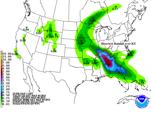
NOAA/HPC QPF map valid for Saturday 12Z – Sunday 12Z. Areas of heaviest precipitation is expected over south-central KY and points southward across the Tennessee Valley Region.
The image above is from the HPC showing the heaviest rainfall amounts across south-central and western parts of Kentucky. The further south you reside, the better chance for higher rainfall totals exist.
Highs for today will be much cooler as rain is expected for many across the state. High temperatures will struggle to reach the low to mid 50’s for folks that are already receiving rainfall. The further north and east you live, along with the absence of rain, temperatures will be a bit warmer with high reaching the low 60’s.

SimuAWIPS 2m Temperature and Winds map. Valid for Saturday 22Z.
Tonight we’ll continue to see areal showers across portions of the state with chilly temperatures expected. Overnight lows will drop into the upper 40’s to around 50 degrees across the area with cooler lows for folks along western KY. Showers will continue through the evening and overnight hours and the upper level trough slowly push towards the east. Multiple flood watches have been issued by the NWS in Louisville, especially across south-central Kentucky where creeks, streams will begin to flood while rivers reach minor flooding stages. The latest watches and warnings are below as a Flood Watch has been issued from 8/7 am EDT/CDT – Sunday evening for the areas highlighted in dark green.

Latest Watches/Warning via Louisville NWS.
Sunday will feature more of the same as cooler conditions will stick around as rain chances will continue into the afternoon and evening hours. High for Sunday will struggle to reach the 60 degree mark across many areas, as widespread rain will continue through the day.
—————-
Sunday night: Showers Likely. Low 50º. Northeast winds 5-7 mph. Chance of precipitation: 60%.
Monday: Chance of showers and cloudy. High: 65º. Northeast winds 5-10 mph. Chance of precipitation: 50%
Monday night: Mostly cloudy. Low: 52º. Northeast winds 5 mph.


